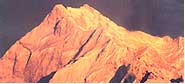
The
Himalaya, roof of the world, is a magic place where the magnificence of
the world's highest mountains is mirrored in the rugged beauty and
unique culture of the people who live in their shadow.
Duration: 06 Nights - 07 Days
Duration: 07 Nights - 08 Days
Duration: 08 Nights - 09 Days
Duration: 09 Nights - 10 Days
Duration: 11 Nights - 12 Days
Duration: 05 Nights - 06 Days
Uttaranchal Glaciers
Nanda Devi Group of Glaciers
| Region : |
Garhwal, Uttaranchal
|
| Altitude : |
7,108m |
| Best Time To Visit : |
Mid April To May-June &
September To November |
Nanda Devi north and Nanda Devi south are two important glaciers, each with
a length of approximately 19-km located in the Rishi Ganga River catchment.
These glaciers originate on the southern slope of Nanda Devi peak (7,108 m).
Other important glaciers in the vicinity are Trishul, Kurumtoli, Nandakna,
Bartoli and Ramani. These glaciers are well developed and are large in size
and length. Several melted-water streams originate from these glaciers and
form the river Rishi Ganga, which later joins the Dhauli Ganga at Raini,
25-km from Joshimath.
Approach To The Glacier
These glaciers are approachable from Joshimath, on the way to Malari road.
Lata, about 25-km from Joshimath, is the last roadhead. From Lata, a bridle
path follows through a dense forest of Pine, Bhoj and other trees and alpine
meadows upto Lata Kharak. From Lata Kharak the route passes through narrow
gorges, steep mountain slopes and sometime through snow patches, to reach
the glaciers snout.
Trek: - BASE CAMP - GANGOTRI TEMPLE
| Gangotri temple to Gangotri Glacier |
17-km |
| |
|
| By Road |
|
| Gangotri to Uttarkashi |
99-km |
| Gangotri to Tehri |
173-km |
| Tehri to Rishikesh |
85-km |
| |
|
| By Rail |
|
| Rishikesh to Gangotri Glacier |
267-km |
| Region : |
Uttarkashi District,
Garhwal, Uttaranchal |
| Glacier Termination Point : |
Gaumukh At 4,000m |
| Altitude Variation : |
6,772m To 6,380m |
| Best Time To Visit : |
Mid April To May-June &
September To November |
Gangotri glacier is a well-known glacier in Garhwal Himalayas, situated in
Uttarkashi district. The glacier originates at the northern slope of
Chaukhamba range of peaks. This is not a single valley glacier, but a
combination of several other glaciers that are fed to it and form a huge
mass of ice. Bhrigupanth (6,772m), Kirti stambh (6,285), Sumeru Parvat
(6,380m) respectively and ratavana bamak, chaturangi bamak and swachand
bamak lie on the northeast slope of Srikailash, Man Parvat, Satopanth and an
un-named group of peaks.
The glacier lies within a span of 28-kms and terminates at Gaumukh
(4,000m). The glacier flows at a gentle slope except for a few ice walls and
crevices developed in the upper regions of the glacier where, as in the
lower part (above the snout), the glacier is covered by debris, which
imparts a muddy appearance to its surface.
Approach To The Glacier
The glacier is easily approachable. It is well connected by motorable road
upto gangotri temple and from there a 17-km long bridle path follows along
the right bank of the Bhagirathi River to Gaumukh, the snout of the glacier.
| Region : |
Bageshwar District,
Kumaon, Uttaranchal |
| Glacier Termination Point : |
3,627m |
| Altitude Variation : |
3,600m To 5,000m |
| Best Time To Visit : |
Mid April To May-June &
September To November |
The Pindari Glacier, in the Bageshwar district, falls in the Kumaon
Himalayas and has lured mountaineers and trekkers since the last century. It
is one of the most easily accessible of all the Himalayan glaciers. Pindari's
rugged beauty offers a breathtaking sight, especially for the trekker who is
in love with nature in all its pristine glory. The Pindari glacier is an
unsurpassable and an exhilarating experience.
A Glacial Beauty
It lies between the Nanda Devi and Nandakot peaks and terminates at an
altitude of 3,627m. The glacier is 5-km long, the snout is about 6 m high
and 2.5 m wide and above the snout, the glacier extends for about 3-m in
length and 300-400 m in width, between an altitudinal range of about 3,000 m
to 5,000 m. the Pindari glacier is located in the Pinder valley between
longitudes 790 13'-800 02' E and latitudes 300 15' N. It
occupies an area of 339.39-sq-kms.
The Pinder River that emerges from the Pindari glacier drains the valley.
The river, in its initial course, flows through sedimentary rocks. Further
to the south, it meanders through quarts schists. Granite is found in
abundance in this area. The Pinder River has cut a gorge in thick glacial
deposits upto nearly 10-km, resulting in the formation of spacious glacial
terraces spread on both sides of the gorge. Further down, from Phurkia up to
khati, places enroute to the pindari glacier, one comes across numerous
waterfalls, hanging valleys and tremendous rolls cliffs as the one of at
Dwali.
Approach To The Glacier
One has to go by road upto song, which can be accessed, from Almora,
Bageshwar and Kathgodam and thereafter one has to trek 45-km upto zero point
(Pindari glacier). The colour of Pindari glacier is very white and at some
places, spots of light blue and brown may also be seen.
Trek: - BASE CAMP - SONG
Song to Loharkhet
Loharkhet to Dhakuri
Dhakuri to Khati
Dhati to Dwali
Dwali to Phurkia
Phurkia to Pindari Glacier |
3-km trek
11-km
8-km
11-km
7-km
7-km |
| Total |
45-km |
| |
|
| By Road: - |
|
| Song to Bageshwar |
36-km |
| Song to Almora |
109-km |
| Song to Kathgodam |
199-km |
| |
|
| By Rail :- |
|
| Kathgodam to Glacier |
244-km |
| Region : |
Kumaon, Uttaranchal |
| Glacier Termination Point : |
3,627m |
| Altitude Variation : |
6,860m To 6,236m |
| Best Time To Visit : |
Mid April To May-June &
September To November |
The scenic beauty and the tranquility prevailing in this region has an
unbeatable charm. The Kaphini glacier lies left of the Pinder valley below
the famous peak of Nandakot. The route to Kaphini glacier covers the same
track upto Dwali, as the trek to Pindari. Kaphini glacier is 12-km from
Dwali via Byali Udiyar, which is at a distance of 8-km.
From Dwali as compared to Pinder the valley is much broader and the
rhododendron that blooms here is spectacularly beautiful. The main Himalayan
summits visible from the glacier are Nandakot (6,860 m.) and Nandabhnar
(6,236 m). There are no rest houses beyond Dwali on the Kaphini track, so
one has to use tents. Byali Udiyar is an ideal spot for a night's stay,
because there are grasslands pitch a tent and caves for a convenient night
halt.
Approach To The Glacier
To reach the glacier, one should start very early from Byali Udiyar 4-km
away, so as to arrive at the zero point before 9 a.m.
Trek: - BASE CAMP- SONG
|
|
Song to Kaphini Glacier
Song to Loharkhet
Loharkhet to Dhakuri
Dhakuri to Khati
Khati to Dwali
Khati to Dwali |
45-km
3-km
11-km
8-km
11-km
12-km |
| |
|
| By Road: - |
|
| Song to Bageshwar |
36-km |
| Song to Almora |
109-km |
| Song to Kathgodam |
199-km |
| |
|
| By Rail :- |
|
| Kathgodam to Glacier |
244-km |
| Region : |
Kumaon, Uttaranchal |
| Altitude : |
4,000m |
| Best Time To Visit : |
Mid April To May-June &
September To November |
To the west of the Pindari glacier, situated on the southern slope of the
Sunderdhunga Khal, is the 5-km Long Maiktoli glacier. This glacier forms the
source of the river flowing on the steep slope for about 25-km before
joining the Pindar River at Dhakuri meadows.
Approach To The Glacier
The west of Maiktoli glacier is the Mrigthuni glacier, situated on the
southern slope of the Mrithuni, Devtoli peaks. It is a 6-km long flow
towards the S-E direction of the valley, with the snout opening at elevation
of 4,000 m and as a stream, meeting the Sunderdhunga river at Sunderdhunga
(3,206-kms) after a trek of 8-km. Towards Khati village upto Jaitoli and a
bridle path along the western side of the Sunderdhunga, one reaches at a
point from where the Maiktoli and the Mrigthuni glacier become approachable.
Trek: - BASE CAMP - SONG
| Song to Maiktoli Glacier |
44-km |
| Song to loherkhet |
3-km |
| Loherkhet to Dhakuri |
11-km |
| Dhakuri to Khati |
8-km |
| Khati to Glacier |
22-km |
| |
|
| By Road: - |
|
| Kathgodam to Glacier |
243-km |
| Region : |
Kumaon, Uttaranchal |
| Altitude Variation : |
6,100 m To 6,856 m |
| Peaks Belong To This Glacial Region :
|
Tharkot, Mrigthuni,
Maiktoli And Panwalidwar |
| Best Time To Visit : |
Mid April To May-June &
September To November |
One can also trek to the Sunderdhunga glacier while in the Pindar region.
It is a touch trek as compared to Pindari and Kaphini. Sunderdhunga means
the valley of beautiful stones. This valley is situated to the west of the
Pindar valley and has two glaciers to offer to trekkers and nature lovers,
namely Maiktoli and Sukhram. The route upto village Khati is common for both
Pindari and Sunderdhunga glaciers. The peaks, which offer a spectacular view
when seen from here, are Tharkot (6,100m), Mrigthuni (6,856m), Maiktoli
(6,803m) and Panwalidwar (6,663m).
Approach To The Glacier
Sunderdhunga is approximately 24-km from the village Khati. From Khati one
has to go to village Jatoli, which is 7-km away. Jatoli is the first night
halt en route to Sunderghunga glacier. From Jatoli upto Dhungia Dhaun, about
8-km is a tough trek. One should spend the night in Dhungia Dhaun either in
shepherd huts or in pitched tents. Beyond Dhungia Dhaun, it is necessary to
take a guide even for experienced and professional trekkers. The next halt
is Kathalia, which is 6 to 7-km from Dhungia Dhaun. From Kathalia one can go
to both Sukhram and Maiktoli glaciers. They are in opposite directions, 7-km
from Kathalia.
Trek: - BASE CAMP - SONG
| Song to Sunderdhunha Glacier |
54-km |
| Song to Loharkhet |
3-km |
| Loharkhet to Dhakuri |
11-km |
| Dhakuri to Kathi |
8-km |
| Kathi to Sundardhunga Glacier |
30-km |
| |
|
| By Rail :- |
|
| Kathgodam to Glacier |
253-km |
Milam Glacier & Ralam Glacier
| Region : |
Kumaon, Uttaranchal |
| Altitude : |
2,290m |
| Milam's Significance : |
Source Of Milam River &
Is A Tributary Of The Pindari River. |
| Best Time To Visit : |
Mid April To May-June &
September To November |
Situated on the south-facing slope of the main Himalayan range is the 16-km
long, Milam glacier. It originates from the slope of Kohli and Trishul
peaks. It acts as the source for the Milam River and a tributary of the
Pindar River.
Approach To Ralam Glacier
The glacier can be approached from Bageshwar and Pithoragarh upto Munsyari
by road. A bridle path nearly 50-km upto Burfu and further 10-km is a route,
which approaches the glacier.
Trek: - BASE CAMP - MUNSYARI
| Munsyari to Lilam |
12-km |
| Lilam to Bagudyar |
13-km |
| Bagudyar to Railkot |
12-km |
| Railkot to Martoli |
5-km |
| Martoli to Burfu |
9-km |
| Burfu to Milam village |
8-km |
| Milam to Milam glacier |
5-km |
| |
|
| By Rail :- |
|
| Kathgodam to Glacier |
374-km |
| Region : |
Kumaon, Uttaranchal |
| Altitude : |
2,290m |
| Significance : |
Source Of Milam River &
Is A Tributary Of The Pindari River. |
| Best Time To Visit : |
Mid April To May-June &
September To November |
Approach To The Glacier
The uppermost catchment of Ramganga east is lesser known and the least
travelled region of Kumaon. It is also among the more difficult trekking
areas of the higher Himalayas. In one day, one reaches Bala village near the
famous Birthi falls on the Thal Munsyari route. On the second day, one can
stay at Thala Bugyal.
On the third day before reaching Sudam Khan one has to go through Thal -
Thunk, Chafua, Ranthan and Malla Ranthan. On the fourth day after crossing
Rahli, Nandakund and the ascent to Rumadhar, the trekker reaches Hiramani
glacier. The fifth is the memorable day as one sees the snout of Namik
Glacier and the lesser stream coming down from Anargal to meet the main
stream, after passing through Jogi Udiyar the ascent of Bhindawali and
Penthang.